
Scenic Routes in Buffalo Bill’s Cody/Yellowstone Country
CODY, Wyoming, June 12, 2017 – Though we’ve evolved from station wagons to SUVs, and paper maps to Google maps, the great road trip vacation has not changed that much over the years.
The Heart Mountain Interpretive Center depicts life for World War II Japanese Americans who were incarcerated.
With Scenic Byways leading The Chief Joseph Scenic Byway to the town’s two closest entrances to Yellowstone National Park and multiple roads with historic sites and natural wonders heading into town, the region is a road tripper’s dream.
Here are some reasons why Yellowstone Country is a must-take driving trip:
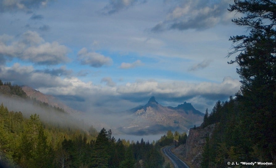
Chief Joseph Scenic Byway and Yellowstone’s Northeast Gate. Driving in or out of Yellowstone National Park’s northeast gate can be a remarkable wildlife-viewing opportunity as the road travels through Yellowstone’s Lamar Valley, called “America’s Serengeti.” It is typical to see bison and elk in this valley and not uncommon to spot wolves, bears, coyote, bighorn sheep, moose and a wide variety of birds. Stops between Cody and the park include the small towns of Silver Gate and Cooke City, Mont. and the Chief Joseph Scenic Byway. Sights along this route include the single-span Sunlight Creek Bridge, the highest bridge in Wyoming and Dead Indian Pass overlook area where the Nez Perce tribe outran the U.S. Cavalry for several months in 1877. History buffs should also consider taking a side trip on the Sunlight Basin Road (a gravel road) to see the Sunlight Ranger Station, a Civilian Conservation Corps structure built in 1936.
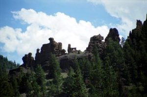
Rock formations along the Buffalo Bill Scenic Byway are fun to spot.
Buffalo Bill Scenic Byway and Yellowstone’s East Gate. The road between Cody and the east entrance of Yellowstone National Park also affords some of the best wildlife viewing in the region, and the rock formations and lava flows with names – provided by imaginative locals – such as “Old Woman and Her Cabin,” “Laughing Pig Rock,” “Snoopy the Dog,” and “Chinese Wall” provide some geological levity. This road trip takes travelers along U.S. Highway 14-16-20 through the valley east of the park in Shoshone National Forest, the country’s first designated national forest and home to the oldest ranger station and past Pahaska Tepee, Buffalo Bill’s hunting lodge. Travelers see the eastern half of the park with easy access to Yellowstone Lake, Hayden Valley, the Grand Canyon of the Yellowstone River, Dunraven Pass and Lamar Valley. Road trippers often combine this route with the aforementioned Chief Joseph Scenic Byway.
Bighorn Basin. South of Cody are badlands and Meeteetse, a tiny Western town known for its charm and lately, its chocolate. Cowboy, dedicated chocolatier and local celebrity Tim Kellogg’s shop, The Meeteetse Chocolatier, serves up preservative-free truffles in wide-ranging combinations. South on Highway 120 is the town of Thermopolis, home of the world’s largest free-flowing hot springs.
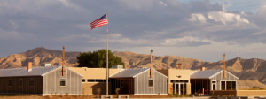
Bighorn Mountain. This road makes its way through the towns of Powell and Lovell and the Bighorn Canyon National Recreation Area as well as the Pryor Mountain Wild Horse Range, home to more than 120 free-roaming wild horses. Along the way is the mysterious 74-foot stone circle called the Medicine Wheel, which some people think had religious or astronomical implications to ancient tribes and the town of Greybull, named for a legendary albino bison bull that was sacred to American Indians in the region. Some of the world’s finest dinosaur fossil beds are nearby, too. Head out to the Heart Mountain Interpretive Center, just north of Cody. This educational facility is located on the site of a Japanese American internment camp that housed some 14,000 people during World War II.
For complete details about all five scenic drives, visit https://www.codyyellowstone.org/things-to-do/scenic-byways/.
###
Yellowstone Country is comprised of the towns of Cody, Powell and Meeteetse as well as the valley east of Yellowstone National Park.
The area of Park County is called “Buffalo Bill’s Cody/Yellowstone Country” because it was the playground of Buffalo Bill Cody himself. Buffalo Bill founded the town of Cody in 1896, and the entire region was driven and is still heavily influenced by the vision of the Colonel. Today its broad streets, world-class museum Buffalo Bill Center of the West and thriving western culture host nearly 1 million visitors annually.
Related hashtags:
#YellowstoneCountry
#CodyWyoming
#CenteroftheWest
#BuffaloBill
#Yellowstone
#Wyoming
Media contact:
Mesereau Travel Public Relations
(970) 286-2751